
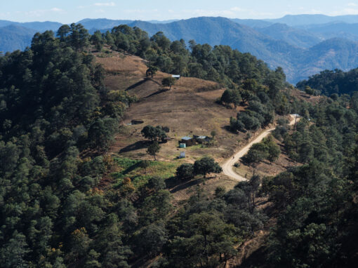
A few years ago, Nicolas Legoretta and I rode two loops around the Reserva de la Biósfera Tehuacán-Cuicatlán, a biosphere that straddles the states of Puebla and Oaxaca. Both of these routes are published on Bikepacking.com, and you can find them here and here.
Last week, Emma and I decided to re-ride the northern route, as there’s a botanical garden – the stunning Jardín Botánico Helia Bravo Hollis – that she wanted to check out. Of course, I took this opportunity to trawl the internet for gpx files in the hope of finding additional dirt roads to weave into the route, only to realise that Tehuacan has a thriving mountain bike scene. As a result, this latest version includes a fantastic singletrack connector from the city that I found on Trailforks. Plus, it’s now much easier to combine the route with public transport from Oaxaca, Puebla, or Mexico City, as you can ride straight out of the bus station, spending only 15 minutes negotiating the city before hitting dirt and trails!
Amongst other changes, the route now features a half-day ‘Cactus Loop’ out of Zapotitlán Salinas, a fantastic ride that traces a yearly local race, called the Reto de Los Cactus. This addition serves to inject some welcome singletrack vibes into the desert experience – we’re talking flowy, cross-county trails through corridors of columni cacti and a few burly arroyo crossings for good measure. It’s a loop that’s a real highlight of riding in the biosphere, so I’d encourage you not to skip it!
The new version also flips the direction of the way we rode it initially. In hindsight, clockwise is best, due mainly to two road segments that are shared with fast traffic – this means you’ll be mostly descending rather than climbing, thus spending less time on pavement. It also allows you to visit the Jardín Botánico Helia Bravo Hollis on your first day in the biosphere, lending you the knowledge to identify some of the many weird and wonderful plants that you’ll see along the way.
I’ll update the route on Bikepacking.com in due course, but in the meantime, find this latest RWGPS track below, along with a breakdown of our itinerary, and the places where we stayed and the dispersed camping spots we used. The original route is the place to go for added POIs, though these could do with an update. I’ll load in some more pictures at some point too – the ones below are mostly transplants from my Instagram Stories.

Wow! Incredible trails from Tehuacan to Zapotitlan! Who would have known that Tehuacan is such a desert trail paradise!


Taking a tour around the wonderful Jardín Botánico Helia Bravo Hollis. Pedro Miranda has been guiding since he was 17, and knew the area inside out.


A riding highlight: the ‘Cactus Loop’ that traces a local race. Drop your bags at a hotel or camp spot for maximum fun!


Take me to your leader. These otherwordly Patas de Elefante can be 500 years old (and provide stout props for leaning bikes).

Hold on… have I just teleported to the Arizona Trail?


Beyond Zapotitlan, in the village of Los Reyes, beautiful new coffee cups were purchased from artists Adela & Julián…

… and used for morning brews the next day.

Dust was collected…

Portals were peeked through…

And bikes were (occasionally) pushed into the twilight…

(it’s always worth it to wake up in a sublime camping spot, right?)

Paletas, made from locally harvested cactus fruit, were especially appreciated, as there’s no better way to temper the desert heat…

Plants of all shapes and sizes and pointiness were inspected and admired…


(including this guy, our neighbour on the last night we camped)

And a couple of hundred kilometres of primo dirt roads and trails were ridden in this wonderful and magical biosphere.

Can you tell I was missing Huesos? This is the longest I’ve been without him in quite some time.
The Route
Note that this route differs from the one we posted to Bikepacking.com. I’ll update it when I get the chance, but in the meantime, use this one to navigate from, along with the POIs from the original version! The track has a few small glitches, but nothing you can’t figure out on the fly. I’ve included a separate track for the Reto de Los Cactus, as we accidentally rode through a small ranchito at around km 19; the race route picks its way around it.
Considering the additions, I’d no longer to consider this a ‘beginner’s loop’, which is how I first described it. Additionally, it’s definitely better suited to a mountain bike than a gravel bike.
Here’s a suggested itinerary, but you could easily spend an extra night in San Juan Rayas too, as there are lots of places to visit nearby, and an official spot to camp. Zapotitlán is a great base to spend another day too.
- Day 1: 58.3 km, 1077m, leave early, riding from Tehuacan to Zapotitlán Salinas, visiting the botanical garden, then riding the Cactus Loop (starts at km 30) in the late afternoon when the light is glorious!
- Day 2: 57.3km, 1650m to possible dispersed camping.
- Day 3: 52.3 km, 1067m to possible dispersed camping, with the possibility of a tour in San Juan Raya.
- Day 4: 20km, 200m, a short day, with plenty of time to ride to the ADO bus station for the journey home.
Field Notes
In case you’re in any doubt… it’s well worth riding the Reto de Los Cactus, aka the Cactus Loop! The version I’ve included in this loop is the 2022 race loop and it’s incredibly scenic, featuring lots of primo singletrack – but there’s a 65km race too, which has more dirt roads and traces parts of the bikepacking loop. Expect the trails to be mostly flowy but chunky and challenging in places too, so bring your mountain bike.
In fact, I’d recommend dropping off your gear in a hotel (we liked Hotel El Calvario, 400 pesos for a double with bathroom, the owner is especially characterful and will be thrilled if you order one of his delicious pizzas!) or at a campsite, and heading out to ride it unladen. There are a number of technical moves along the way, and a few very short hike a bikes too. The loop took us 2+ hours riding time (plus lots of stops for photos and plant inspection). It really is a fantastic ride, and a highlight of this area as it takes you into an unblemished zone of columni cacti and patas de elefantes. Don’t skip it! (-;
On day 1, don’t skip a visit to the Jardín Botánico Helia Bravo Hollis either! It’s 45 pesos for Mexican citizens and 90 pesos for overseas visitors. This includes a guided tour (our guide was extremely knowledgeable), with a just propina to add in. I think we were there for about 2 hours. It’s time very well spent, as it will teach you all about the various plants that you’ll see along the route, as well as aspects of the indigenous history in this region. Zapotitlán Salinas is also great spot to sample ancestral cuisine from the region, much of which features desert flora and various types of grubs. Restaurant Itandehui Flor de Cielo has a particularly colourful menu!
On day 2, we really enjoyed visiting one of the pottery workshops of Los Reyes, a village known for its barro bruñido. Save some room in your panniers as the work is exquisite; it’s burnished and polished by stone to give it a particular finish that’s different from the pottery in Oaxaca. We bought couple of mugs and wrapped them in our sleeping bags!
If you have some time on Day 3, I’d recommend joining one of the dinosaur footprint tours in San Juan Raya. The shortest take about an hour. Check in at the community centre and they’ll organise it. All the tours are very affordable and it’s money that goes straight into the community.
Day 4 is short, leaving you plenty of time to get to Tehuacan, hit a coffee shop or comedor, and wait for your onwards bus.
Whilst much of this bikepacking loop is rideable on gravel bike (with appropriate gearing and tyres), there’s enough chunky trails and steep pitches to warrant a mountain bike. Certainly, the route from Tehuacan into the biosphere is far better suited to a mountain bike, as is the delightful Cactus Loop. This area is rife with thorns, so best to go tubeless, for sure, and top up with sealant before you head out.
Note that this delicate biosphere isn’t protected or preserved in the same ways as say, a national park in Europe and or the US. Expect to see villages and farms along the way, and quarries too. In places, there’s a fair amount of trash by the roadside, so please do your best not to add to it by trying to minimize your single use plastics, or even packing it out.
Most of this route has little to no traffic. However, there are two short but potentially busy road segments (especially at the weekends). We’ve found drivers to be cordial but still, I’d recommend bringing some daytime lights and high viz clothing.
Security wise, we felt very safe in this area. However, it’s worth noting that people we met suggested we take care in Tehuacan, particularly in the evenings. As always, be discreet with your camera/phone and don’t flash your cash around. If in doubt, ask for up to date beta on the area, as security in Mexico can change quickly.
Getting there
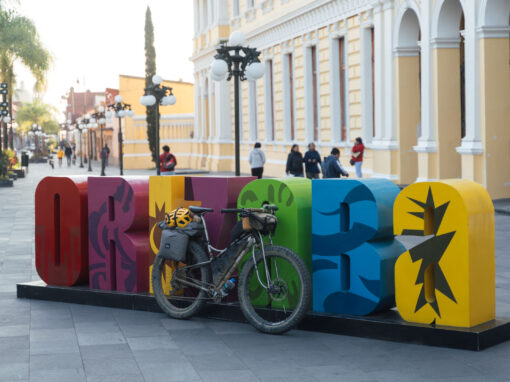
We favor the ADO bus line, as there are rarely any issues fitting bikes in the luggage compartments (at least, I’ve never had any so far, after many, many bus rides!) There’s an ADO app that you download and book through – this allows you to pick a bus that’s not too full. I remove the front wheel and drop the saddle to make it easier to fit everything in, this way bikes can be positioned upways, so they’re well protected.
Tehuacan is easy to get to from Mexico City and Puebla. However, there are only a few daily buses between Oaxaca and Tehuacan – ours was direct and took about 3.5 hours. If you’re heading to Tehuacan from Oaxaca, it may well work out best to arrive in the evening, spend the night in the city, and get cracking in the morning. Itinerary-wise, this will line you up well to catch an afternoon bus back to Oaxaca. At the time of writing, it’s about 600 pesos to travel between the two cities, and there are plenty of affordable hotels in Tehuacan to choose from.
Josh
2 February 2023 at 5:13 pm
Route looks amazing! I’m planning to ride Norte route in a couple weeks with CDMX-based friends. We’ll likely incorporate these updates!
What would you say is minimum recommended tire size? I’ve got a gravel bike with 700x42mm tubeless currently. Much of route seems like ideal gravel for my setup, but unsure if I’ll be having a bad time on the added singletrack or elsewhere. Can fit up to 700×50 if needed (else find a 650b wheelset!). Not afraid of a bit of hike-a-bike…
Cass
2 February 2023 at 9:34 pm
Great! I think the updates are definitely worth it. The day ride wends into an area that’s quite stunning and more protected/untouched than the periphery of the biosphere. It’s especially dense with patas de elefantes, and the singletrack through the columni cacti is wonderful. The access route from Tehuacan is also super fun. If you prefer, you can exit the loop back to Tehuacan via a dirt road, if you don’t want to repeat the arroyo crossing. It would likely be something like this, albeit in reverse:
https://ridewithgps.com/routes/41832700
Although there are plenty of smooth, well-packed sections, and a couple of short stints on pavement, the route is actually surprisingly chunky in places, even without the additions. I’d definitely fit 50s if you have them, and expect to push in a few places. Most local riders have hardtails of some kind.
Jesse Kirby
11 February 2023 at 7:16 pm
Hey there Cass, I am Jesse and my partner is Ellen. We visited Oaxaca last April and are missing the Tlayudas so much that we are heading back there, within the year! Last round we bussed to Oaxaca, did the Grand Dirt Tour, and another zip back to Teotitlan for some rugs to take home. A nice two-week venture. This trip, also two weeks, starts next Thursday! (Feb 15th) we are planning to base from Puebla and start with the Ojos De Tehuacan. Then carry on to the Oaxaca Escondido route for some beach time. Friends from Santa Fe mentioned that I should drop you a line and see how things are going for you down there. By the looks of the routes you have been making, I’m guessing, pretty good. Anyway, any suggestions you might have about current conditions or to-do’s in Puebla would be great. Or if you care to arrange a meetup that would be awesome. Happy trails!
Cass
12 February 2023 at 12:38 am
Hi Jesse,
Great! It’s a super fun ride, especially with the additions (see map above). By mid Feb, it will be getting on the warm side I expect, but that will be the same in Oaxaca too, so as long as you carry plenty of water, should be fine. I bet there are regular buses from Puebla to Tehuacan. If I’m around, I’m always up for an early morning ride with Huesos!
Pingback
Kristin Moretz
3 October 2023 at 4:52 pm
This route looks amazing! Will definitely be trying it in late October with some friends. Is there a good place for rentals in Tehuacan? We won’t have bikes with us and are trying to figure out the logistics of that. We will be coming from Oaxaca, but would love to rent locally if you know anywhere.
Cass
5 October 2023 at 9:52 am
Hm, I don’t know Tehuacan well enough to really comment… but my gut feeling is that it’s unlikely. There could well be in Puebla. Otherwise, Oaxaca is an option – I’ve Iisted some places here:
https://stilloutriding.com/2022/10/general-info-for-bikepackers-in-oaxaca/
Juan
16 January 2024 at 6:05 pm
Hi Cass, thanks for the update. I have two questions. I plan to do this route in April. According to your experience, what do you think the weather will be like during that season?
And the second question: Is there any way to connect this loop with the southern loop?
Cass
16 January 2024 at 8:44 pm
I haven’t ridden there that late in the dry season, but I imagine it’s pretty hot! Perhaps best to see what Google says.
For linking ideas, take a look here: https://stilloutriding.com/2022/10/bikepacking-routes-in-oaxaca/
Pam Grifffin
2 February 2024 at 1:47 am
We are on our way! Any problems with goatheads or other thorns?
Cass
2 February 2024 at 2:05 am
Have fun!
We didn’t spot many goatheads, but there are thorns galore. Top up with sealant, for sure!
For the Reto del Los Cactus route, there’s no need to return to town via the highway. The last section of trail is super fun in the reverse direction too!
Cass
2 February 2024 at 2:30 am
One other thing. There are a couple of small glitches on the main file, nothing too serious and easy enough to figure out. I’ll edit them out when I get home!
Where the route traces the Reto, there’s a spot were we accidentally ended up in a small ranchito (very friendly owner), so I’ve added in a RWGPS file for the official route, which picks its way around it.
abhay
5 February 2024 at 7:54 pm
Hello Cass, I am planning to ride this route in november first week of 2024.
Are there any bike rentals available? I will be visiting mexico city for 2-3 days before heading out to oaxaca for this bikepacking route. I can bring my bikepacking gear but renting a bike over there would save a hassle.
Cass
6 February 2024 at 5:13 pm
Hi! I only know of places to rent bikes in Oaxaca City. Info here:
https://stilloutriding.com/2022/10/general-info-for-bikepackers-in-oaxaca/
Note that this route is across the border in Puebla state, rather than Oaxaca…