
For more on the preparation behind this route, see this blog post on our time in Orizaba.
Here’s the final version of the route, as posted on Bikepacking.com.
I’ve aspirations to write this trip up in longform or as a route for Bikepacking.com, seeing as it turned out so well and I took so many photos. But in the meantime… here’s the rough RWGPS map and a few details to keep it company.
Huge thanks are due to 1/ Alain, for the inspiration to explore this area and ride up to the tippy top of Volcán Sierra Negra (Tliltépetl) in the first place and 2/ to Javier at Stoned Riders for checking through the route and offering many alternatives and improvements. In fact, Javier is so stoked on this loop that he’s off to bikepack it himself in February – we’ll see what adjustments he comes up with. Fun fact: the road to Sierra Negra, atop which sits the Gran Telescopio Milimétrico (at almost 4600m), is the highest road in Mexico! I figure it must be one of the longest climbs to get there too, seeing as the lowest point on the route is just 900m. It’s a monster!
As I mentioned, I took far too many photos, so for expediency’s sake, here’s a rehash of the IG Stories that I posted while we were out there, and a few other images to fill in some gaps. Because yeah, I hauled my laptop up from 900m to almost 4600m, and back down again! Thankfully it survived the jostles and bumps.
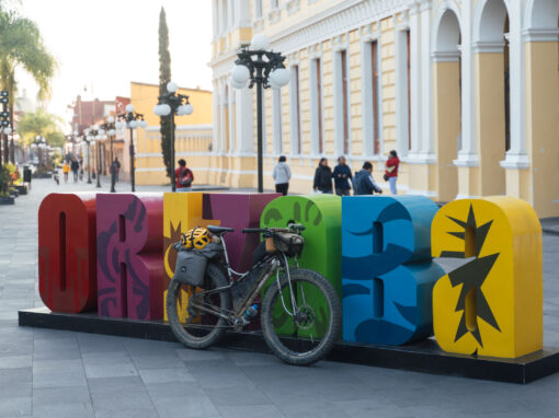
You can find our itinerary below. I’ve marked places we stayed on the map, along with other potential spots and possible improvements to the route. And, you can read more about Orizaba, where we started the ride (along with our favourite eateries and coffee shops), over here.

Initially, our route out of Orizaba dropped us down from 1200m to 900m, from where we began a slow and steady climb that would take us to Refugio Piedra Grande at 4200m, and eventually (considerably) higher.

Riding through the coffee plantations above Fortín de las Flores, guided by Javier of Stoned Riders aboard his Surly Krampus. And a would-be-Huesos.

Minimum pavement. Maximum dirt. It’s a winning formula.


We spent the afternoon in the Pueblo Magico town of Coscomatepec. There’s that volcano again, peeking out over the rooftops of our hotel. At 5636m, it’s the third-highest peak on the continent.

Slowly closing in on Pico de Orizaba the next day.

This is rugged and dusty country. Here’s the Jones LWB Spaceframe bedecked with a Tumbleweed Mini Pannier Rack and a set of MLD panniers (plenty of space for my laptop and extra layers). Cadillac ride, despite all the bumps, courtesy of 29 x 3.25in tyres.

Sunshine! And what a spot for a Coffee Outside. On Day 2, we paused at the Rio Jamapa in the Parque Nacional Pico de Orizaba (a national park since 1937) to make breakfast. Then the road deteriorated, so we were off the bike and pushing.


It took a while, but we finally made it up to Refugio Piedra Grande on the north side of the volcano, a climbers’ enclave that lies at 4200m. The volcano’s glaciers are seen most clearly from this direction. The surroundings were windswept, bare, and remote. I felt like I could have been in Ecuador, or somewhere deep in the Andes. Hard to believe it’s so close to Oaxaca.

Then we were back down in the valley, ready to winch up once more. That’s Pico de Orizaba to the left and Sierra Negra to the right, which we intended to summit via Mexico’s highest road.

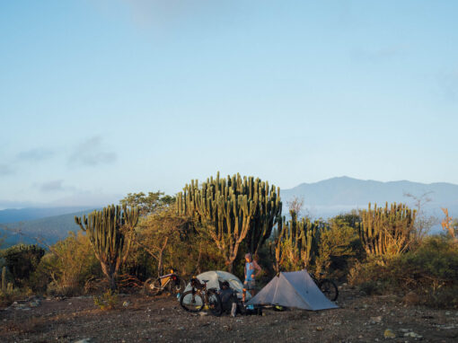
That night, our camp spot was primo and we could see the observatory high above us. It took a while to get riding in the morning though. No one was going anywhere until that sun hit the tent and coffee had been imbibed…


Mission accomplished! 600m of O2-deprived climbing later, we made it up to the Large Millimeter Telescope. We celebrated our arrival by cooking up some porridge, making ourselves comfortable in the dirt, in true bikepacker fashion. This telescope is one of a number around the world that probe deep space for black holes and other space oddities. In the past, I’ve also marveled at the Very Large Array in New Mexico, which can be seen along the New Mexico Off Road Runner bikepacking route.


4560m according to the Wahoo… Let’s call it 4600m!

Then it was back down, again, with Pico de Orizaba rarely far from view.

Javier had shared a gpx file for an alternative route off the mountain, and it was a doozie!

Dirt (and dusty) road bliss. We’re talking ankle-deep dirt (and dusty) road bliss.

Here I am, always a sucker for a painted wall, making friends in Hotel Rasario, Atzitzintla. (Don’t tell Huesos)

Colour coordination like this doesn’t come by chance, you know.

Full of ideas, Javier suggested we trace the old railway line down to Maltrata. And what a ride it proved to be. Completely traffic free for hours, we paused to inspect all kinds of cool historical titbits along the way.


Eek! Do we have to cross this?! Thankfully no, as there was also a scrappy piece of singletrack that hugged the hillside. Apparently, someone has driven across this ‘bridge’ in a jeep (insert brain explosion emoji).

More historical relics. Just look at those tiles from the substation before Maltrata. I don’t expect they build them like that anymore.


One less truck.

As we had plenty of time to get back to Orizaba, we did our very best to follow the train line all the way in, keeping to dirt tracks where we could.

What a ride!!! Dustydustdust! Without a doubt, one of my favourite loops in Mexico so far.
The Route
The map has lots of POIs that include a couple of potential route shortcuts and where we stayed. I’ll add in other camp spots that we scoped out but didn’t use. Not that there might be a small fee to pay to access the park – it depends if the booth is open, or if anyone comes around and charges you. You’ll be given a bracelet to show you’ve paid.
This was how we broke the route up. You could do it faster for sure, but it actually worked out really well, as it gave us plenty of time to explore the area, take breaks and photos, and not be in too much of a rush. We were also figuring out a few route changes on the fly, which caused a couple of delays. You could easily make it to the refugio on day 4 (which would allow for an earlier start the next day), but we preferred to camp out.
The area above Maltrata is known for being a zona caliente due to illegal tree felling, so be sure you’re only riding through there during the daytime. Same goes with the route into Orizaba. This loop works best in the direction we rode it, thanks to some extended sandy sections.
- Day 1 – 47 km, 965 m, 3:28hr (shortish day, afternoon visiting Coscomatepec)
- Day 2 – 34.5 km, 1,797m, 3:45hr (almost all climbing, camping)
- Day 3 – 41.2 km, 1,220m, 3:32hr (dropped down to Tlachichuca for the night)
- Day 4 – 39.6 km, 1,630m, 4:14hr (camped up near refugio)
- Day 5 – 39.5 km, 875m, 3:33hr (2033m down!)
- Day 6 – 51.4 km, 183m, 3:06hr (1535m down!)
Field Notes
Day 1 initially has a stint on the highway, but it’s mostly down, so goes by quickly. Then Javier pointed us in the direction of Coscomatepec, via dirt roads and coffee plantations. We were happy to arrive early and have some time in town.
Day 2 was all about climbing. Technically, it’s mostly paved, but we found enough dirt to break it up, so it didn’t feel like too much of a chore. We actually planned to get into the national park and camp there (see map for the road we’d intended to take) but ended up falling a little short, due to a late start. Still, no shortage of climbing!
Day 3 was fantastic – a sizable climb (and push, in places) up to the Refugio Piedra Grande, past some lovely picnic spots. We didn’t plan to drop down all the way to Tlachichuca (I’ve marked places to stay in Miguel Hidalgo and San Miguel Zoapan that’s not as far down, if you book in advance, and a campspot in a forest before San Jose Llano Grande). But it ended up working out for us as I could get some work done, and it’s a good spot for a resupply.
Day 4 was really dusty for one section (we avoided a shortcut that looked especially bad see map), a few stints on pavement, and lots of dirt road climbing (small sections of which are dusty) to a sublime camp spot. Cold! Expect temperatures to drop below freezing. Also, carry lots of water (maybe 4L) for the climb for Day 5, as this side of the volcano is completely dry.
Day 5 started with the climb up to Sierra Negra (as we were camping, we had to wait a while for the sun to hit and warm us up) then a fantastic descent, thanks to Javier. Definitely a highlight. We wondered if we might make it all the way back to Orizaba that day, but we soon realised it would be way too much of a rush. Instead, we stayed in Atzitzintla (there’s a friendly, economical hotel there) so we weren’t riding at dusk or at night.
All of which meant we could really enjoy Day 6, meandering along the old railway line to Maltrata, and following the train tracks all the way into Orizaba, arriving there a little after lunch.
If you do this ride, please get in touch and let me know how it went. Drop a line to Javier too, he may have other ideas for you!


I forgot to mention that one of my hydraulic brakes became non-functional halfway around the route, so no rear brake on the 3400m descent! Thanks to everyone at Power Bike for getting me up and running again. What a great bunch of riders.
Chris
15 July 2023 at 12:00 am
Amazing ride. Amazing photos. I live in Baja and completed the Baja Divide last year. I want to do the ride from CDMX to Sierra Negro and then the loop you posted above. I’d love to correspond and ask a question if possible. Thanks for the incredible post.
Cass
15 July 2023 at 9:41 am
Hi Chris,
Thanks!
I tried to put everything I know about the ride in this post, but if there’s anything you want to ask, feel free to fire away!
This is the first time we visited the area. I do plan to return at some point and ride the route again, but it won’t be for a few months. We really enjoyed it as it is, but I’m sure there’s room for changes and improvements – a few are suggested within the RWGPS map. Javier from Stoned Riders has ridden a version with more trails, so if that appeals, get in touch with him.
There’s some more info on Orizaba here, too:
https://stilloutriding.com/2023/01/orizabo-ing/
Pingback